


Andrews Chapel Voting District, Lauderdale County, Mississippi
About
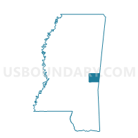
Outline

Summary
| Unique Area Identifier | 605961 |
| Name | Andrews Chapel Voting District |
| County | Lauderdale County |
| State | Mississippi |
| Area (square miles) | 14.78 |
| Land Area (square miles) | 14.69 |
| Water Area (square miles) | 0.09 |
| % of Land Area | 99.40 |
| % of Water Area | 0.60 |
| Latitude of the Internal Point | 32.50378610 |
| Longtitude of the Internal Point | -88.65136320 |
Maps


Graphs
Select a template below for downloading or customizing gragh for Andrews Chapel Voting District, Lauderdale County, Mississippi


Neighbors
Neighoring Voting District (by Name) Neighboring Voting District on the Map
- Bailey Voting District, Lauderdale County, MS
- Daleville Voting District, Lauderdale County, MS
- New Lauderdale Voting District, Lauderdale County, MS
- Obadiah Voting District, Lauderdale County, MS
- Prospect Voting District, Lauderdale County, MS
Top 10 Neighboring County Subdivision (by Population) Neighboring County Subdivision on the Map
- District 1, Lauderdale County, MS (17,748)
- District 3, Lauderdale County, MS (16,946)
- District 2, Lauderdale County, MS (15,435)
Top 10 Neighboring Place (by Population) Neighboring Place on the Map
Top 10 Neighboring Unified School District (by Population) Neighboring Unified School District on the Map
Top 10 Neighboring State Legislative District Lower Chamber (by Population) Neighboring State Legislative District Lower Chamber on the Map
- State House District 84, MS (25,092)
- State House District 81, MS (22,670)
- State House District 42, MS (20,974)
Top 10 Neighboring State Legislative District Upper Chamber (by Population) Neighboring State Legislative District Upper Chamber on the Map
Top 10 Neighboring 111th Congressional District (by Population) Neighboring 111th Congressional District on the Map
Top 10 Neighboring Census Tract (by Population) Neighboring Census Tract on the Map
- Census Tract 102.02, Lauderdale County, MS (7,761)
- Census Tract 103.01, Lauderdale County, MS (5,382)